
The 4th ERT Spatial Ecology and Conservation Conference (SEC4) was held on the 12th – 14th July at the University of Bristol. Delegates from across the world gathered to present their work and to discuss the latest developments in all-things related to spatial ecology, conservation, policy and practice. The conference, led by Dr. Mark O’Connell from ERT (Ecological Research Training Ltd.) included seminars, workshop sessions, side-events and plenty of opportunity for discussion. Participants of the three-day conference were a balanced mix of researchers, practitioners, academics and policy-makers; many came from the UK, but there was a clear international focus with a number of delegates attending and presenting from across Europe, South Africa, Thailand, Australia and the USA amongst others. Introductions were made at the sunny University of Bristol campus, and conversations quickly turned to discussion of the participants’ various different backgrounds, from ecological research and teaching of key tools in remote sensing and GIS, to the application of these tools and knowledge for real-world practical management and conservation of species, habitats and landscapes.
The event kicked off on the morning of the 12th. Here we take a look at some of what was presented, activities that were run and key take-home messages from the first 4 symposia. There’s a lot to say and the latter 4 symposia will be covered in the autumn edition of the ialeUK newsletter!
Symposium 1 – Marine Spatial Planning
The keynote presentation was given by Dr. Paul Gilliland, Head of Marine Planning at her Majesty’s Government. Paul introduced the importance of marine planning in governance at a global scale, highlighting the need for a collaborative and integrative approach in our seas to deliver sustainable development that works for all sectors with environmental, social and economic interests. The talks and break-out discussions that followed focused on mapping and valuing the marine environment to inform spatial planning. Examples included the conservation of albatrosses and large petrels in South Georgia, Antarctica (University of Cambridge) while Anita Franco (University of Hull) highlighted how we can identify ‘hot-spot’ habitats that have high ecological value for supporting key fish life-stages. Michael Shackshaft (Wildfowl and Wetlands Trust) in collaboration with Natural England and MacArthur Green also presented SeaMaST (Seabird Mapping and Sensitivity Tool) which is designed to provide evidence of UK seabird populations and to map seabird sensitivity to impacts from offshore wind farms. The vulnerability maps (Figure 1 below) reflected well the amassed distributions of the most sensitive species, and SeaMaST has application to wider geographical areas and relevant human activities. Find out more by clicking on the SeaMaST link above.
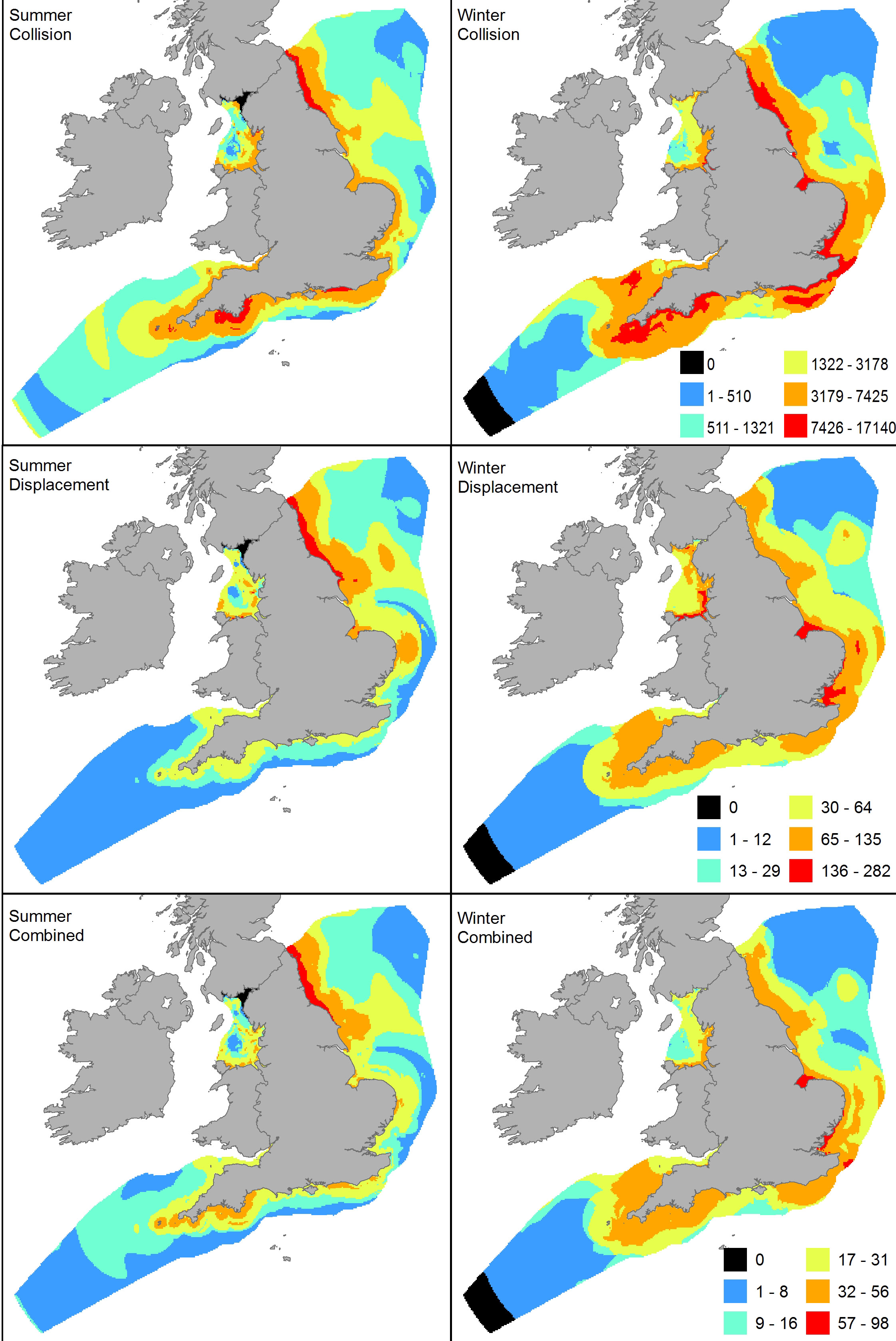
Figure 1 (above): Windfarm sensitivity maps for SeaMasST taken from Bradbury et.al (2014) PLOS ONE/WWT consulting.
Symposium 2 – Food webs at the landscape scale
Talya Hackett (University of Bristol) led this session; her keynote focused on how food webs can be structured across different habitats at a landscape scale. Specifically, she highlighted that more diverse landscapes which contain a mosaic of different habitat types are more robust to disturbance and provide a greater range of ecosystem services (a key theme at this year's conference).
The scientific research focus continued with talks highlighting the use of biological recording data to identify national patterns of plant pollinator networks (CEH), the response of zebras to fluctuations in resource availability (Wageningen University) and flexibility in foraging behavior as a possible response to climate change (Queen Mary University). Three workshops followed which fostered discussions on key issues relating to landscape scale networks and sought to answer a leading question of the morning… do fish pollinate? (The short answer is yes!)
Symposium 3 – What practitioners want: spatial data to detect and measure change at nature reserves and landscapes
Led by Lucy Rogers from Avon Wildlife Trust, this session was very popular amongst consultants, policy-makers and practitioners alike! Lucy highlighted the difficulties in detecting change as the long-term evidence collected remains quite poor and a gap still exists between research and practice. So how can we fix this? One answer is site-level smart working whereby organizations share data collected by members, volunteers and through citizen science – check out the Wildlife Trusts Living Maps in Figure 2 below and WildWalks and WildSurveys. Discussion also highlighted the value of student placements and many organizations expressed an interest in collaborating with Universities and Research Institutions to help use and apply the data they have collected. Academics, researchers and practitioners alike were keen to see this avenue explored and we implore all those that are interested to make contact with nearby organizations and institutions and foster new relationships.
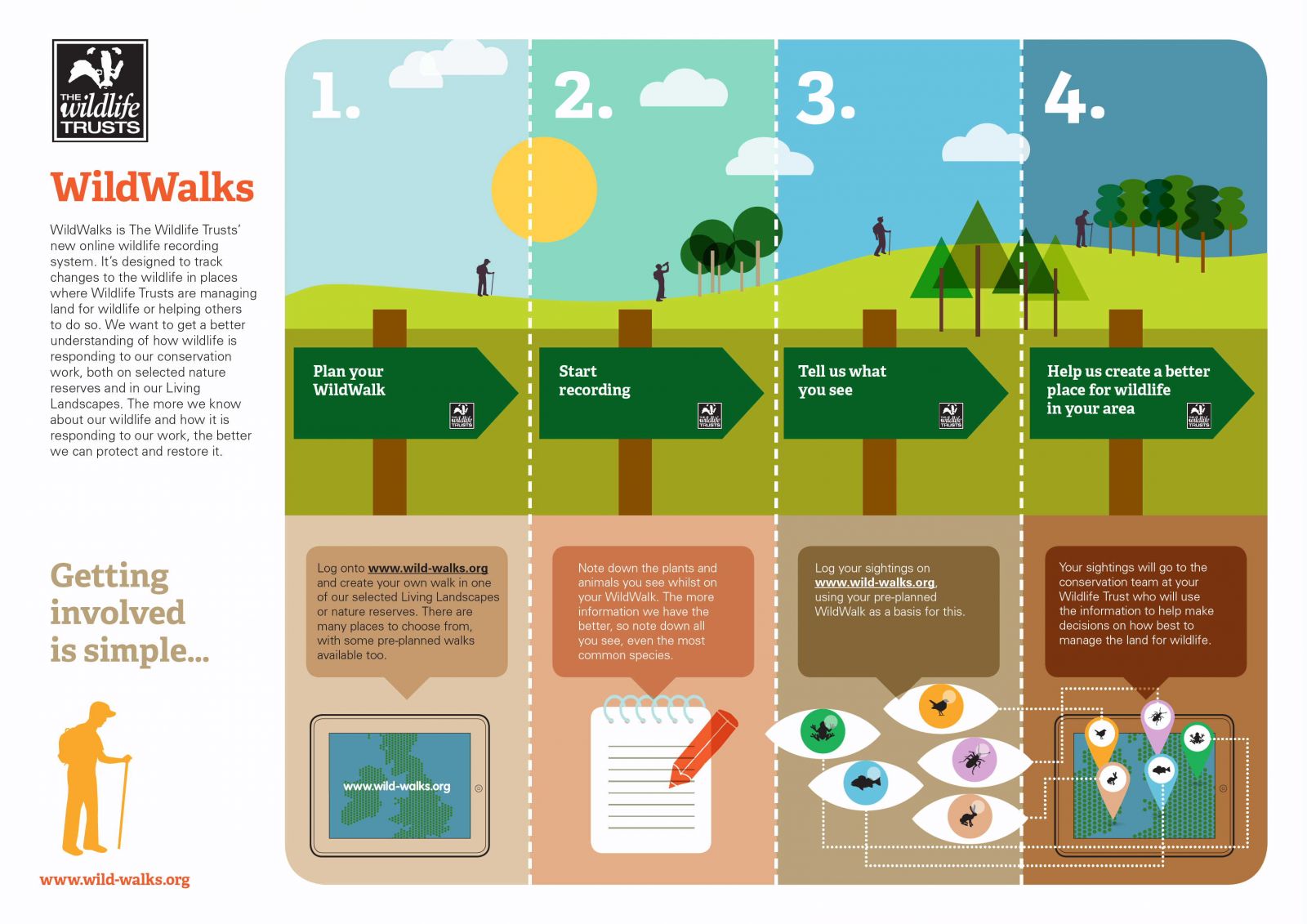
Figure 2 (above): Wild-walks Infographic - online recording know-how.
Tying in nicely, the second talk was by Jo Judge, the new CEO of the National Biodiversity Network (NBN) whose priority is to improve the availability of high resolution, high quality data for environmental decision-making. Jo introduced the new NBN Atlas – currently only available for Scotland but with plans to roll out as a UK-wide platform, the Altas of Living Scotland allows users to upload and verify their records, consult an image gallery, explore their local area and undertake analyses of data. (see seperate article by the NBN in this newsletter edition). A fantastic website in its early stages of development , this may end up being THE future portal for data records, rolling Magic, iRecord and the original NBN Gateway into one!
Other talks in this symposium included a presentation on Vegetation Trend Analysis by Christopher Hancock from Somerset Wildlife Trust – a highly useful piece of software to assist in the management, creation and restoration of important botanical sites. Niamh McHugh from the Game and Wildlife Conservation Trust discussed the effect of agricultural habitat quality on tree sparrow breeding performance, while Cornwall Wildlife Trust and Exeter University introduced the advantages (and drawbacks!) of using remote sensing technology for local level conservation management.
Remaining in the technical zone, the symposia was rounded off with an introduction to BioScore 2.0 (PBL Netherlands Environmental Assessment Agency, Sovon Centre for Field Ornithology, Dutch Butterfly Conservation and Sapienza University of Rome) who developed a model to assess the effects of biodiversity policy option on future species distributions in Europe. First results indicate that climate change has a larger impact on terrestrial biodiversity loss than landuse change or changes in pressures…discuss!
Symposia 4 – Using ‘R’ for spatial analysis
An enlightening session on the use of R for conservation, mapping, modelling and decision support – proving that the R packages are leading the way in spatial ecology and conservation! Lex Comber from Leeds University provided the keynote, encouraging conservation and environmental scientists to wear ‘geography goggles’ through which to view the world; he states “do not expect relationships to be the same everywhere, and do be interested in finding out how and where things vary…” The Centre for Environment, Fisheries and Aquaculture Science discussed the application of an R tool to assess accuracy when mapping intertidal habitats, while Chloe Bellamy from Forest Research presented their work on modelling the impact of green and grey development on urban pollinator habitats using the R ‘sdm’ package. The aim is to help inform green infrastructure and target citizen greenspace initiatives to improve the city of Edinburgh for both pollinators and people. Find out more about the role of Forest Research in the EU Green Surge project and the Edinburgh Living Landscape here.
Birdlife International introduced their tool to identify sites of conservation importance for seabirds using foraging areas of individually tracked birds, and Victor Mose (African Conservation Centre) presented the use of database tools for decision support in the Amboseli, Kenya. Currently, research in the Amboseli relies on the collection of local data, which has to pass through the community resource centre and be analysed in a central lab in the city. Their plan is to engage with local communities, teach them the tool and shorten the data analysis path so that decision-making to help alleviate grazing pressures and monitor populations can be achieved quickly and efficiently.
Short summaries of the key issues, trends and future directions to come out of the R symposia were:
“Tool transparency is needed”
“Demand for an R-users group to help develop a network of knowledge”
“Horses for courses – use R, but don’t forget you can go elsewhere too!”
“Remember, models are only predictions, not the absolute truth”
If you’d like to download the full programme and abstracts from SEC4, you can do so here.