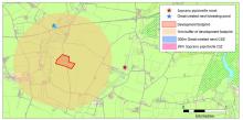
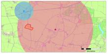
There was a good article published in the December issue of the Chartered Institute for Ecology and Environmental Management (CIEEM) magazine, contributed by the Bat Conservation Trust. This highlighted a number of important issues concerning how species distribution data is used to inform planning decisions. Currently this often involves a search for previous records of protected species within a single search radius of a proposed development, typically within 1-2km but in some circumstances up to 10km. However the use of a single search radius fails to take account of the fact that different species can have vastly different movement ecology. This approach can miss records of protected species occurring outside the search radius, but whose home-ranges potentially overlap the development site. At the same time it can return records of other species which, as a result of the distances over which they typically move, are not likely to be impacted by the development. The example was given for soprano pipistrelle bats Pipistrellus pygmaeus and great crested newts Triturus cristatus (see Figure 1 and 2). Soprano pipistrelles will typically travel up to 2km from their roost each night to forage, so a search for bat records within 1km of a development could miss records of bats that are at risk of negative impacts from the development. However, great crested newts rarely travel more than 500m from their breeding ponds in terrestrial habitat so, provided there are no other ponds in the vicinity, the risks to great crested newts from a development outside this typical movement radius are lower. The limitations of current practice can lead to a misleading assessment of the likely impacts of a development on vulnerable species, and a greater risk that valuable habitat will be damaged or destroyed.
An alternative approach is suggested based around the idea of a Core Sustenance Zone (CSZ). This is the area of land needed for key activities (such as commuting and foraging for bats), estimated using the ecology and typical movement radius of the species. The concept of CSZ facilitates a shift towards landscape scale thinking. For bats the CSZ is defined as the area surrounding a communal bat roost within which habitat availability and quality will have significant influence on the resilience and conservation status of the colony. To some extent this approach is not new, ecologists will naturally think in this way when assessing the potential presence of species on and adjacent to the development site. However formalising this approach will help ensure species distribution data are used appropriately in planning, and that these decisions are based on sound scientific and ecological evidence. The use of species distribution data, including how concepts such as CSZ could be implemented in practice, is being considered by the Partnership for Biodiversity in Planning, a cross-industry partnership of 17 key organisations representing the planning and conservation sectors. To find out more about this project please contact kboughey [at] bats [dot] org [dot] uk.
Adapted from an article by Jan Collins, Lisa Hundt and Katherine Boughey, Bat Conservation Trust, published in issue 86 (Dec 2014) of In Practice, the quarterly magazine of the Chartered Institute of Ecology and Environmental Management.