")
Planting 50 million trees
You may have heard of the Northern Forest! It was all over the news briefly in January. The idea is to plant 50 million trees, over 25 years, across a large area centred on the M62 corridor, from Liverpool to Hull. The idea for a Northern Forest has grown out of a partnership between the Community Forests and the Woodland Trust. The first step was to develop the concept: to identify the opportunities, constraints, benefits and mechanisms of a long term, multi-disciplinary approach to its creation. An important consideration was, of course, landscape ecology. Where should the trees be planted in order to best improve habitat connectivity? What important pathways already exist through the landscape? Do ecological considerations place any constraints on planting?
Using electrical circuit analogy to understand species movement
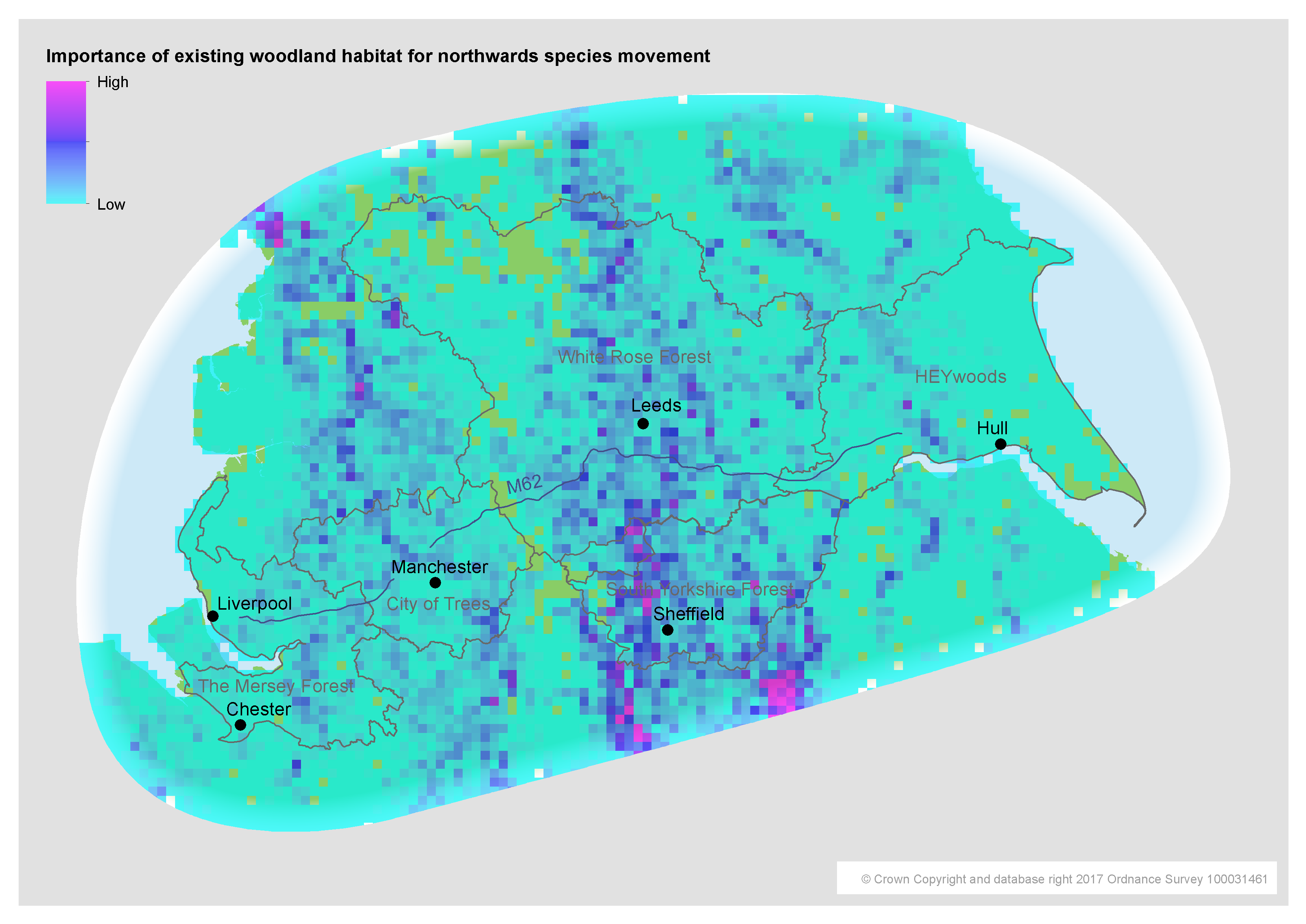
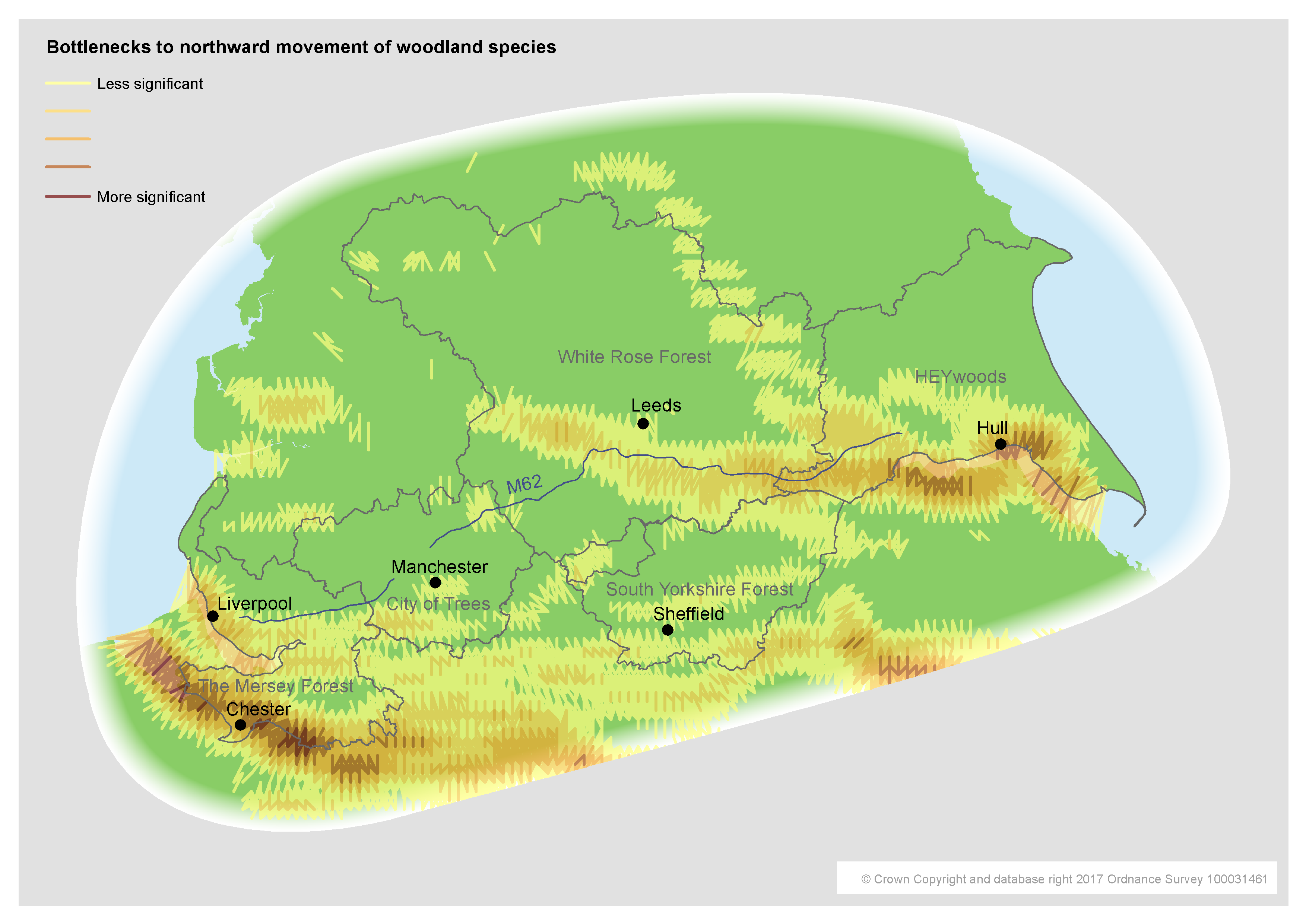
To help answer these questions, we made use of Condatis, a piece of software developed by the University of Liverpool. Condatis is a decision support tool that is used to identify the best locations for habitat creation and restoration. It makes use of an electrical circuit analogy (link to definition) for species movement between habitat patches. The only inputs required are a habitat map, the locations of the ‘source’ and ‘target’ of species movement, and a dispersal distance, and it provides many interesting outputs. Most relevant to us were the flow map, which shows existing dispersal pathways and therefore the relative importance of existing woodland for species movement, and the bottlenecks map, which effectively suggests locations where tree planting could have maximum impact.
Datasets, resolution and dispersal distances
Since our primary focus was woodland, we used the Forestry Commission’s National Forest Inventory as the source data for our habitat map. This impressive dataset includes the boundary of every woodland in Great Britain larger than 0.5 hectares. In order to achieve sensible processing times in Condatis for a study area as large as the Northern Forest, it was unfortunately necessary to limit the resolution of the derived habitat map to 2km. (A forthcoming web-based version of Condatis promises to allow higher resolutions relative to the study area size). For the source and target we chose the southern and northern edges of the study area respectively, to model the northward movement of species that we might expect with climate change. The default 4km dispersal distance was used. The first map below shows the importance of existing woodland habitat for northwards species movement. The second map shows bottlenecks in northward movement of woodland species.
Bottlenecks and habitats
An interesting feature of the bottlenecks map (link to more information) above is the emphasis on the estuaries of the Dee, the Mersey and the Humber, where planting is impractical. They come out because Condatis has no knowledge of the distinction between open water, mudflats etc, and other locations without existing woodland. However, this is not necessarily a weakness of Condatis, as the estuaries may well constitute real obstacles to the movement of certain woodland species, and planting to help circumnavigate them may well be valuable. Other bottlenecks appear to be focused on agricultural areas. The bottlenecks map was incorporated into an overall Northern Forest targeting map, which brought together all of the considerations that we were able to map, from flooding to mental health. This has been shared widely and will hopefully influence targeting of future funding.
For more information:
Northern Forest overview ( link to download pdf )
Northern Forest prospectus ( link to dowload pdf )
Condatis: ( link to website or link to article summarising a recent knowledge exchange workshop )
Tom is a GIS Coordinator and web developer at The Mersey Forest, specialising in green infrastructure mapping and online mapping applications. He can be contacted at: tom.butlin@merseyforest.org.uk