Have you ever wanted to know more about our natural capital and where it is?
The concept of natural capital recognises that the natural environment provides many benefits to people, in terms of our health, wealth and well-being. In recognising that natural resources are a form of ‘capital’, in the same way that ‘built’ or ‘social’ capital are, we ensure that they cannot be ignored in decision making about environmental change.
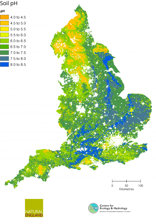
The Natural Capital Committee define natural capital as “the elements of nature that directly or indirectly produce value to people, including ecosystems, species, freshwater, land, minerals, the air and oceans, as well as natural processes and functions”. With an ever increasing interest in natural capital there is a need to understand the important elements of natural capital which underpin our well-being and where they are located. With the aim of making the best available maps of natural capital widely accessible, Natural England and the Centre of Ecology and Hydrology (CEH) have produced a suite of ten maps of terrestrial natural capital in England.
The natural capital maps are are available at a 1km resolution available through dedicated web pages on the CEH website.
Open-source GIS data on Natural Capital
The web-pages provide the facility to view and download the maps, as images and GIS compatible data at a 1km scale. Each map shows a different aspect of natural capital, e.g. soil carbon, nectar plant richness for bees or headwater stream quality, based on the characteristics of the 1km square. An accompanying report for each map summarises what the map is showing, how it relates to the provision of ecosystem services and how it has been created.
The maps have been produced using CEH’s Ecomaps statistical model which has been published in the academic peer reviewed press. The model uses two key CEH data sources. The first is the Land Cover Map, which uses interpreted satellite imagery to provide habitat information for OS polygons across the whole rural area of England (and the rest of the UK). The second key dataset is CEH’s Countryside Survey data which provides detailed, statistically rigorous, plot level information on habitats for a nationally representative sample of habitats across England (and GB). The project builds on the approach used in Natural England’s mapping of ecosystem services project: Assessing the potential for mapping ecosystem services in England based on existing habitats - NERR056, which mapped broad habitat types and their importance for the provision of ecosystem services, based on expert opinion from the UK National Ecosystem Assessment. The use of modelled variables, based on detailed spatially representative information on habitats, provides the best available comparative national picture of natural capital.
Scientific data presented for use by practitioners
Through working together, Natural England and CEH have incorporated the use of additional natural capital data sets, besides those based on broad habitats (as in the previous Natural England project). A real strength of the collaborative working has been the bringing together of academics and practitioners. This has enabled the scientific data and evidence to be presented in an easily accessible form, for use by practitioners, so that they can have a good understanding of what the data shows.
Work in progress
Both Natural England and CEH consider their mapping of natural capital to be “work in progress”; we are keen to explore how we can further add to this series and how we can use them to help conserve our natural capital. CEH are continuing work to explore how their vast array of national and sub-national datasets can help to further our understanding of where our natural capital is and how it underpins ecosystem services provision. They are also working with local stakeholders to explore how CEH data could contribute to decision making at local scales, through different modelling approaches.
Jane Lusardi is a Senior Specialist in the Ecosystem Approach and Natural Capital at Natural England, email: Jane.Lusardi@naturalengland.org.uk
Lisa Norton is head of the Land Use Group and Countryside Survey at CEH, email: lrn@ceh.ac.uk